SA Tomorrow

San Antonio is planning boldly. We're tackling the tough issues and making hard choices because "business as usual" isn't good enough. We are planning now to ensure that the great City of San Antonio captures the type of growth and economic development that is compatible with our community's vision of the future and provides benefits to all our current and future residents.

What is SA Tomorrow?

By 2040, San Antonio's population is expected to increase by approximately 1 million people. SA Tomorrow is an innovative, three-pronged planning effort to guide the city toward smart, sustainable growth. Explore this website to learn about the SA Tomorrow Plans and our ongoing plans for the City's Regional Centers and Community Areas.

Comprehensive Plan

The Comprehensive Plan addresses land use, urban design, and municipal policy to coordinate City resources and incentive programs to pro-actively accommodate projected growth and provide more choices for current and future residents.

Learn More

Sustainability Plan

The Sustainability Plan focuses on the three pillars of sustainability (economic, environmental, and social) and is the roadmap for both the community and the municipal government to achieve the overall vision of a sustainable San Antonio.

Learn More

Multimodal Transportation Plan

The Multimodal Transportation Plan is a dynamic, balanced, and forward-thinking plan for all modes of transportation, including cars, transit, bicycles, and pedestrians. It communicates the City's transportation strategy and serves as a tool to analyze transportation priorities to best meet community goals.

Learn More

SA Tomorrow Sub-Area Plans

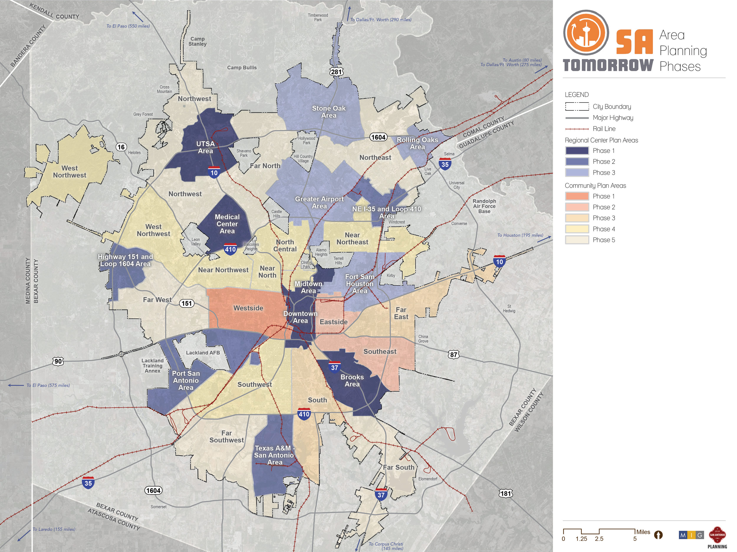
The SA Tomorrow Comprehensive Plan addresses wide ranging and interconnected citywide issues. As a long range vision for San Antonio, the Plan provides strategic direction for decision making and community investment. Following adoption of the Comprehensive Plan in August, 2016, the Planning Department is working with communities to create Sub-Area plans for the 13 Regional Centers and 17 Community Areas that collectively cover the entire City of San Antonio.

The Regional Center and Community Area Plans will address the following topics: Land Use; Parks and Open Space; Economic Development; Housing; Mobility and Infrastructure; Placemaking and Urban Design; and Policy and Investment Priorities.

Click on the hotspots for information.

Regional Center Plans

Regional Centers are one of the major building blocks of San Antonio’s city form and a focus of the overall SA Tomorrow effort. While most cities have one or two larger employment centers, we have 13. This provides challenges and opportunities. A major organizing principle of the City’s Comprehensive Plan is to focus growth in these Regional Centers, building on the existing pattern of development. They are envisioned as new “places” where we live, work, and play.

Ongoing Regional Center Plans

The Brooks Area Regional Center is a community of pioneering spirit; with a history influenced by colonial missions, early flight schools & aeronautical medicine. This resilient, pioneering spirit has led the Brooks Area into the forefront of economic activity for the Southside; turning adversity into opportunity by redeveloping Brooks City-base, now a major catalyst for growth on the south side of the City and the anchoring namesake for Regional Center. The Brooks area continues to be cutting edge and forward-thinking; placing emphasis on collaborative & sustainable strategies which benefit the environment, health and wellbeing, education and overall quality of life for the future.

Learn More

The historic and cultural center of the City and home to the world renowned Riverwalk. Downtown is the center of San Antonio’s traditional economy anchored by the tourism, education and health care industries.

Learn More

The Fort Sam Houston activity center includes the Fort Sam Houston military base and also large parts of the City’s older industrial lands along I-35. Fort Sam Houston is a designated Historic Landmark and one of the Army’s oldest installations. Fort Sam is also home to the Brooks Army Medical Center, which is also the only US Department of Defense Level I Trauma Center in US. The activity center is home to over 62,000 jobs, of which 40,000 are military jobs.

Learn More

Centered around the San Antonio International Airport and the confluence of Highway 281 and I-410, the Greater Airport Area Activity Center has the most employment of all regional centers. While SAIA is a major employment asset for the City, the Greater Airport Area center actually has more employment (estimated at 60%) that is not airport related. The area includes large concentrations of office uses and major retail destinations, which makes this area the most economically diverse center.

Learn More

One of the City’s four emerging activity centers, the area has been the center of major development activity over the past decade.

Learn More

The Medical Center Area is not only a primary hub of medical related services and education in San Antonio, but also provides an abundance of job diversity and housing choices. The Medical Center area has the potential to become a leading example for a vibrant, well-connected regional center for people to live, work and visit.

Learn More

Where downtown and historic north side neighborhoods meet, the headwaters of the San Antonio River and San Pedro Springs Creek, with premiere museums, parks, and colleges, Midtown is where diverse San Antonians live, work, and play.

Learn More

The I-35 corridor in the northeast portion of San Antonio has traditionally been the industrial employment center of the City.

Learn More

This center includes the existing Lackland Air Force Base and the redevelopment of the former Kelly Air Force Base, known as Port San Antonio.

Learn More

Located north and east of the intersection of I-35 and Loop 1604 in northeast San Antonio, the Rolling Oaks Area Regional Center is one of four emerging Regional Centers. Major industrial and commercial employment centers serving this area include: Green Mountain Industrial Park, Rolling Oaks Mall, Walmart, and nearby IKEA (in Live Oak, TX). The regional center’s large amount of undeveloped and vacant land presents an opportunity to add a significant number of new residents and jobs by 2040. This growth will be supported by its prime location at the entrance to San Antonio and its superior connectivity to regional highways.

Learn More

The Stone Oak Area Regional Center is located at the confluence of Highway 281 and the N Loop 1604. This regional center includes several established master planned neighborhoods and numerous amenities located to the east and west sides of Highway 281. There is a mixture of uses with over 21,000 jobs and 65,000 residents in the area. It offers a wide variety of attractions, services, and amenities, including parks with active and passive recreational opportunities, quality medical care facilities, top-notch education, and premium retail centers.

Learn More

One of four emerging Activity Centers in City, this center is anchored by the new Texas A&M San Antonio Campus and the Toyota manufacturing campus.

Learn More

Anchored by the University of Texas at San Antonio, the UTSA Activity Center is the center of entertainment and retail for the northern portion of the City. Located at the intersection of I-10 and the 1604 Loop, this Activity Center includes major destinations such as Six Flags Fiesta Texas, The Rim Shopping Center and The Shops at La Cantera.

Learn More

Community Area Plans

Community Areas form the rest of San Antonio outside of the Regional Centers. These areas comprise many of our existing neighborhoods, grouped by geography and common history, challenges, and opportunities. By proactively directing a higher proportion of growth to our Regional Centers, we aim to limit the impacts of that growth on existing, stable neighborhoods. However, cities and neighborhoods are always evolving, and we must plan to adapt to and leverage change for all our existing and future residents by creating complete neighborhoods and communities that provide a full range of amenities and services, a variety of housing and transportation choices, and opportunities for employment, shopping, education, and recreation.

Ongoing Community Area Plans

The South Community Area is comprised of many long-standing neighborhoods, businesses, and families who have generational roots in San Antonio. The plan area is historically and culturally rich, and the area is also known for the San Antonio Missions National Historic Park.

Learn More

The Eastside Community Area is a group of historic and dynamic places and neighborhoods that are home to thousands of San Antonians.

Learn More

The Far East Community Area serves as an eastern gateway into San Antonio with both established and emerging neighborhoods. Far East is home to several key community amenities and industrial hubs that anchor a diverse range of people.

Learn More

The Near North Community Area includes engaged neighborhoods that help create a strong sense of community. This area has a mix of residential and commercial properties, notable long-established institutions and churches, well-maintained parks and trails, public art and murals, tree-lined streets and walkable areas throughout. There are several historic places and buildings throughout the Near North community with distinctive architectural styles that remind us of different eras and development patterns that evolved over time. This community includes the River Road, Monte Vista, Monte Vista Terrace, Alta Vista, Beacon Hill, Monticello Park, Martinez Creek, Jefferson, Maverick, Woodlawn Lake, Keystone, and Los Angeles Heights neighborhoods. Well known parks and historic places in this area include Woodlawn Lake, Trinity University, Landa Library, Trinity Baptist Church, and San Pedro Springs Park. The Near North area blends timeless charm with a modern, creative atmosphere.

Learn More

The Near Northeast Community Area is located about 7 miles northeast of downtown San Antonio and borders the municipalities of Windcrest, Kirby, Alamo Heights, and Terrell Hills. The area is mostly residential with new and established neighborhoods. A significant feature of the area is its many regionally significant corridors including Broadway, Austin Highway, Wurzbach Parkway, and Walzem, Eisenhauer, and Rittiman Roads. NE Baptist Hospital, the Salado Greenway Trail, Victoria’s Black Swan Inn, Los Patios, and the McNay Art Museum are amenities that contribute to the area’s quality of life and unique character.

Learn More

The Near Northwest Community Area consists of traditional neighborhoods layouts with diverse architectural styles and large lots. It is also home to St. Mary’s University, the oldest Catholic university in Texas that is embedded in the University Park neighborhood. The area’s convenient location allows views and access to the City’s Downtown and serves as a gateway to the far west and northwest of San Antonio. The area was one of the first suburban developments in the city and has an established sense of community with many amenities for residents.

Learn More

The North Central Community Area is home to a diverse community and group of neighborhoods, including historic streetcar suburbs, mid-century subdivisions, and a broad base of small businesses, local shops, and restaurants. Its location north of downtown and proximity to US 281, Loop 410, and IH-10 provide residents with easy access to the rest of the city by car. The area is home of Olmos Basin Park, one of the largest and most iconic parks in San Antonio, but also to several beloved neighborhood parks such as Kenwood Park, Olympia Park, and Dellview Park, which support local public life and foster a sense of community among neighbors.

Learn More

The Southeast Community Area is full of historic residential neighborhoods and vibrant communities that have been home to generations of San Antonio’s residents and families.

Learn More

The Southwest Community Area is characterized by established neighborhoods near the former Kelly Air Force Base (now Port San Antonio), supported by a long history of industry in the area, and proximity to major regional thoroughfares, such as IH-35 and SW Military Drive. There is a considerable amount of pre-war residential development (houses built before 1940) in the Southwest Community Area, particularly in the Palm Heights neighborhood and near the Quintana community. The southwesterly side of San Antonio continued to experience more development as a result of the establishment of Kelly Field and the continued presence of the Air Force at Kelly Field and Lackland Air Force Base.

Learn More

The West Northwest Community Area, located in northwest San Antonio, offers residents convenient access to Loop 410 and Loop 1604, and major corridors including Bandera and Culebra. This vibrant area is not only anchored by Ingram Park Mall but also boasts a diverse array of public and private amenities, from parks and trails to clubhouses. Extending out to include the natural beauty of Government Canyon State Natural Area, home to the only known dinosaur tracks in Bexar County. The Community Area is home to over 30 unique and established homeowner, community improvement, and neighborhood associations. Residents are active and engaged, contributing to a strong sense of community and a commitment to maintaining the area’s quality of life.

Learn More

The Westside is the traditional heart of the city, particularly for San Antonio’s Hispanic culture. This Community Area embraces a diverse range of people, neighborhoods, and institutions and celebrates numerous cultural, educational, and natural resources.

Learn More

Future Community Area Plans

Far North

More Information

Far South

More Information

Far Southwest

More Information

Far West

More Information

Northeast

More Information

Northwest

More Information

Subscribe for Updates

To subscribe for updates for SA Tomorrow,

Tell Us What You Think


Project Team Lead

Chris Ryerson

Planning Administrator – Citywide Planning Division

(210)207-7833